GEOTECHNICAL ENGINEERING
LEXINGTON
HomeUnderground ExcavationsGeotechnical analysis for soft soil tunnels

Geotechnical Analysis for Soft Soil Tunnels in Lexington

Evidence-based design. Reliable delivery.

LEARN MORE

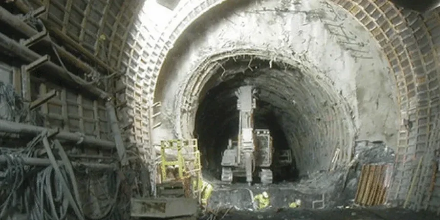
Lexington sits squarely on the Lexington Limestone formation, an Ordovician carbonate rock mantled by thick sequences of residual clay derived from millennia of chemical weathering. This isn't uniform soil—it's a layered profile where stiff, low-plasticity silty clay can transition within meters to zones of completely decomposed limestone riddled with solution cavities. For any tunnel alignment below the water table, which often fluctuates within 10 to 20 feet of ground surface in the Inner Bluegrass, the primary challenge is face stability in clayey soils that slake and soften when saturated. A tunnel boring machine advancing through this material encounters abruptly changing cutterhead torque demands, while an SEM heading can experience crown settlement exceeding predictions if the pre-treatment grouting fails to seal karst conduits. Our geotechnical analysis integrates pressuremeter testing and lab-based residual strength parameters to capture the post-peak behavior of these weathered shales and clays before a single foot is excavated.

Tunneling through residual karst clay demands a design that accounts for post-peak strength loss and the potential for sudden water inflow through solution features.

Our service areas

How we work

The contrast between downtown Lexington and the suburban expansion zones south of Man o' War Boulevard illustrates the variability we manage. In the urban core, tunnel alignments often intercept the Cynthiana Formation—thinly bedded limestone interbedded with calcareous shale that holds up well under drained conditions but can unravel at the face if water seeps along bedding planes. Southward toward the Hamburg area, the overburden thickens and the clay fraction becomes more expansive, requiring shield support pressures tuned to active earth pressure coefficients that shift seasonally with moisture content. We combine advanced triaxial testing on undisturbed Shelby tube samples with in-situ CPT testing to map the transition from stiff upper crust to softer normally consolidated clay at depth, and we correlate those profiles with MASW surveys to identify voids and fractured rock zones before the cutterhead reaches them—reducing the risk of sudden face collapse in mixed-face conditions.
Geotechnical Analysis for Soft Soil Tunnels in Lexington
Technical reference — Lexington

Local geotechnical context

Lexington's growth since the 1960s pushed sewer and stormwater infrastructure deep into the Grier Limestone Member, a unit notorious for its irregular epikarst surface and clay-filled grikes that act as preferential drainage paths. When a tunnel is driven beneath an established neighborhood like Chevy Chase, the historical development pattern becomes a geotechnical risk factor: leaking utility trenches have been saturating the near-surface clay for decades, creating softened zones that collapse under small changes in effective stress. The most consequential risk is not squeezing ground but sudden communication between the tunnel heading and a previously unmapped sinkhole throat—a scenario that can drain a supported face in minutes. Our risk mitigation strategy starts with a detailed karst susceptibility assessment using historical sinkhole mapping from the Kentucky Geological Survey, followed by probe drilling ahead of the face and real-time settlement monitoring tied to trigger levels calibrated to the stiffness degradation curves of the specific clay unit.

Need a geotechnical assessment?

Reply within 24h.

Email: contact@geotechnicalengineering.biz

Regulatory framework

ASTM D1586 Standard Test Method for Standard Penetration Test (SPT), ASTM D2487 Standard Practice for Classification of Soils, ASCE 7 Minimum Design Loads for Buildings and Other Structures, IBC International Building Code (Chapter 18: Soils and Foundations)

Reference parameters

ParameterTypical value
Undrained shear strength (Su) of residual clay25 to 80 kPa
Plasticity Index (PI) range15 to 40%
Groundwater table depth (Inner Bluegrass)3 to 6 m below grade
Karst cavity risk classificationHigh (sinkhole density >5 per km²)
TBM face support pressure range0.8 to 2.4 bar
Maximum expected settlement (crown)< 25 mm with pre-support

Questions and answers

How much does a geotechnical analysis for a soft soil tunnel project in Lexington typically cost?

Based on the scope of investigation and laboratory testing required for tunnel design in karst terrain, the cost ranges from US$4,010 to US$15,270. A smaller-diameter utility tunnel with limited access borings will fall at the lower end, while a large-diameter sewer or transit tunnel requiring extensive pressuremeter testing, triaxial CU and CD tests, and a comprehensive karst probing program will approach the upper range.

What laboratory tests are essential for characterizing Lexington's residual clays for tunneling?

We specify a suite that includes consolidated-undrained triaxial tests with pore pressure measurement to capture undrained shear strength at various consolidation stresses, one-dimensional consolidation tests to define the compression and swelling indices of the clay, and Atterberg limits to correlate with empirical face stability charts. When tunneling through the clay-limestone interface, we add slake durability tests on the weathered shale interbeds.

How do you handle the risk of encountering a karst cavity during TBM advance?

Our methodology begins with a desk study of Kentucky Geological Survey sinkhole maps and historical borehole logs in the corridor. During the site investigation, we run continuous coring and downhole geophysics in boreholes spaced at 50 to 100 feet along the alignment. If cavities are suspected, we recommend a probe drilling program from the TBM cutterhead with a contingency grouting system on board to fill voids before the shield passes through.

What settlement criteria do you use for tunnels beneath Lexington's historic buildings?

We typically adopt a maximum angular distortion of 1/500 for masonry structures in the downtown historic district, which translates to a crown settlement limit often in the range of 15 to 25 mm depending on tunnel depth and building footprint. These limits are verified through a staged 3D finite element analysis that models the building stiffness and the soil-structure interaction explicitly.

Can you perform the geotechnical analysis if the tunnel alignment crosses multiple geologic formations?

Absolutely. Many Lexington tunnel alignments transition from the Lexington Limestone into the underlying High Bridge Group or cross into the Clays Ferry Formation. We subdivide the alignment into geotechnical units based on lithology and weathering grade, define representative parameters for each unit, and model the transitions explicitly in PLAXIS or FLAC3D to capture the change in tunnel behavior at the contact.

Location and service area

We serve projects in Lexington and surrounding areas. More info.

View larger map