GEOTECHNICAL ENGINEERING
LEXINGTON
HomeGeophysicsElectrical resistivity / VES (Vertical Electrical Sounding)

Electrical Resistivity Testing in Lexington: VES Surveys for Karst Terrain

Evidence-based design. Reliable delivery.

LEARN MORE

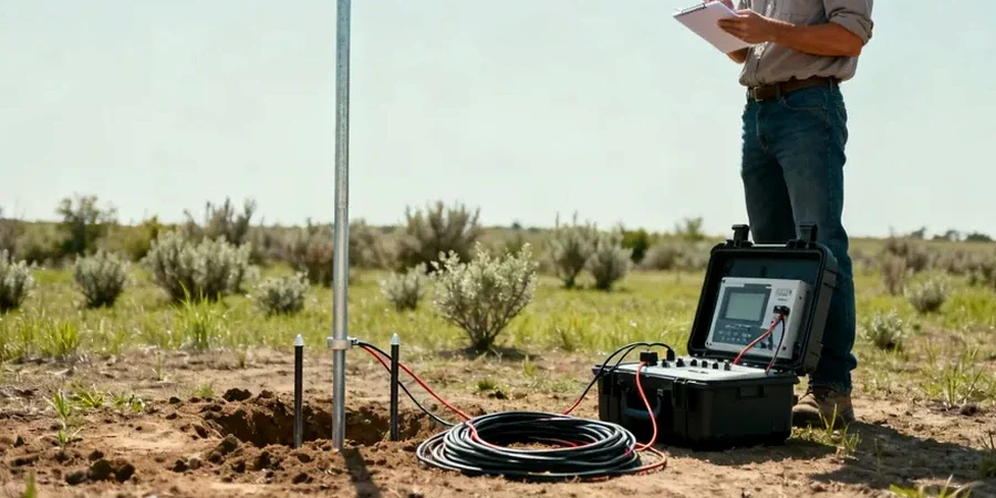
The contrast between downtown Lexington's shallow limestone and the deeper soil cover out toward Hamburg Pavilion is something we deal with constantly. Near Transylvania University you might hit rock at eight feet; head east past I-75 and you can go thirty feet before seeing weathered shale. That variability makes electrical resistivity an essential first-pass tool here. Vertical Electrical Sounding lets us map those transitions without punching a hole in the ground — we run a Schlumberger array across a site and build a layered resistivity model showing where competent rock sits, where clay pockets hide, and where water might be moving through solution channels. For engineers working in Fayette County's karst, that stratigraphic picture changes how you design foundations and stormwater systems from day one.

A single VES sounding in Lexington limestone can distinguish air-filled voids from clay-plugged sinkholes before any excavator touches the ground.

Our service areas

How we work

Lexington sits at roughly 978 feet above sea level on the Inner Bluegrass plateau, and the Ordovician limestone beneath it has been dissolving for millions of years. That geology shows up clearly in a VES curve. We run current through stainless steel electrodes in expanding spreads — typically AB/2 from 1.5 meters out to 150 meters — and measure apparent resistivity at each step. Dry limestone reads high, above 800 ohm-m; clay-filled sinkholes and moist shale drop below 50 ohm-m. The contrast is sharp and repeatable. Our field crew uses a 4-pin Wenner array for shallow mapping and switches to Schlumberger for depth, processing data with 1D inversion software that accounts for Lexington's typical three-layer profile: residual soil over epikarst over intact bedrock. When a site shows lateral variation, we complement the sounding with a CPT profile to calibrate resistivity against direct tip resistance and sleeve friction measurements.
Electrical Resistivity Testing in Lexington: VES Surveys for Karst Terrain
Technical reference — Lexington

Local geotechnical context

Lexington's post-war expansion pushed development south and east across the same karst plain that gives us the Bluegrass horse farms — but also a legacy of sinkhole claims that Kentucky Geological Survey has mapped extensively. The hazard isn't just the void you see opening up; it's the raveling zone above it, where soil has been migrating downward for decades without surface expression. An electrical sounding catches that raveling zone as a transitional resistivity layer before it becomes a collapse. We've surveyed sites near McConnell Springs where what looked like competent clay on a boring log turned out to be a three-meter-deep zone of loosened soil over a growing cavity. Missing that means differential settlement, cracked slabs, and stormwater suddenly disappearing underground. The sinkhole investigation protocol we follow pairs resistivity lines with targeted test pits to verify anomalies, giving you a defensible geotechnical baseline before grading begins.

Need a geotechnical assessment?

Reply within 24h.

Email: contact@geotechnicalengineering.biz

Explanatory video

Regulatory framework

ASTM D6431-18 Standard Guide for Using the Direct Current Resistivity Method for Subsurface Investigation, ASTM D2487-17 Standard Practice for Classification of Soils for Engineering Purposes (Unified Soil Classification System), ASTM D1586-18 Standard Test Method for Standard Penetration Test (SPT) and Split-Barrel Sampling of Soils, IBC 2021 Chapter 18 – Soils and Foundations (karst-specific provisions), ASCE/SEI 7-22 Minimum Design Loads and Associated Criteria for Buildings and Other Structures

Reference parameters

ParameterTypical value
Array configurationsSchlumberger (standard), Wenner (shallow), dipole-dipole (lateral mapping)
Maximum investigation depth80–120 m depending on site geometry and ground noise
Typical AB/2 range for VES1.5 m to 150 m in 20–25 logarithmic steps
Apparent resistivity range5 ohm-m (wet clay) to >2,000 ohm-m (massive dry limestone)
Data processing1D layered inversion (IPI2Win) with RMS error <5%
Electrode materialStainless steel stakes, salt-water contact in dry surface conditions
Applicable ASTM standardASTM D6431-18 (Standard Guide for Using the Direct Current Resistivity Method)

Questions and answers

How deep can a VES survey see in Lexington's limestone?

With a Schlumberger array and AB/2 spacing pushed to 150 meters, we typically reach investigation depths of 80 to 120 meters in Inner Bluegrass geology. Practical depth depends on site access — we need clear space to lay out the full spread — and on background electrical noise from nearby power lines or buried utilities. In urban Lexington neighborhoods with tight lots, we sometimes cap at 40–50 meters and supplement with shallower 2D lines.

What does electrical resistivity testing cost for a typical residential or small commercial lot in Fayette County?

For a standard package of four to six VES soundings on a single residential or small commercial parcel in the Lexington area, costs generally range from US$660 to US$1,090 depending on site size, surface conditions, and whether we're also running 2D tomography lines. We provide a fixed-price proposal after a brief site visit — no surprises after mobilization.

Can resistivity tell the difference between a water-filled void and a clay-filled sinkhole?

Yes, and that distinction matters enormously for foundation design. A water-filled cavity in limestone typically reads between 30 and 80 ohm-m, while a clay-plugged sinkhole drops below 25 ohm-m — sometimes as low as 5 ohm-m in saturated montmorillonitic clay. The resistivity contrast is strong enough that our inversion models clearly separate the two, which tells you whether you're dealing with a drainage pathway or a compressible soil pocket.

How long does a VES survey take, and what access do you need?

A single VES sounding takes about 45 minutes to an hour once electrodes are placed. For a full site with four to six soundings, expect us on the ground for one day. We need walking access to lay out four cables in a straight line — up to 300 meters total for deep soundings — and permission to drive small stainless steel stakes at each electrode position. Tall grass and pavement slow us down but don't stop the work; we adjust contact resistance with salt water or bentonite mud at each pin.

Do you coordinate with the Kentucky Geological Survey sinkhole database?

We reference the KGS sinkhole inventory and karst potential maps on every Lexington project. The database gives us a regional context — known sinkhole density, nearest mapped features, underlying formation contacts — that informs where we place our resistivity lines and how we interpret anomalies. It doesn't replace field geophysics, but it makes our survey design smarter from the start.

Location and service area

We serve projects in Lexington and surrounding areas.

View larger map