GEOTECHNICAL ENGINEERING
LEXINGTON
HomeGeophysicsSeismic tomography (refraction/reflection)

Seismic Tomography (Refraction/Reflection) in Lexington, KY

Evidence-based design. Reliable delivery.

LEARN MORE

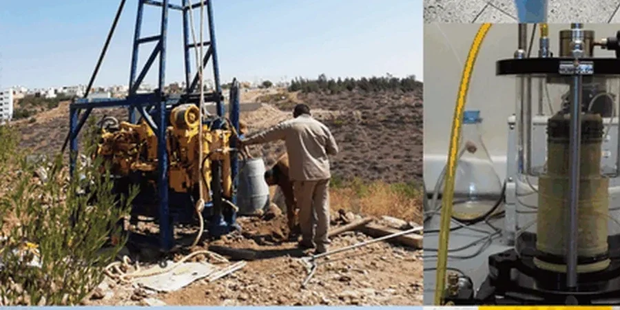
The subsurface contrast between downtown Lexington and the Hamburg area is stark. Downtown near the Kentucky River palisades, the Lexington Limestone sits within 10 feet of grade, often riddled with solution channels from centuries of groundwater flow. In Hamburg, 20 to 40 feet of stiff silty clay overlies the rock, and the transition zone can hide pinnacled bedrock that wrecks grading plans. Seismic tomography cuts through that ambiguity. Refraction profiling maps the soil-rock interface continuously, while reflection sections image deeper bedding planes that control how groundwater moves. For a hospital expansion off Harrodsburg Road we ran three lines across a 4-acre parcel; the tomograms showed an 8-foot-deep trough in the rock surface that borings alone missed. That trough would have required 200 extra cubic yards of structural fill under the mat foundation. The MASW survey gave us the Vs30 for the seismic design category, and the combined dataset let the structural engineer drop one full SDC bracket.

A refraction tomogram reveals pinnacled rock 20 feet away from a boring that showed flat bedrock — that spatial gap is where foundation surprises live.

Our service areas

How we work

Lexington's growth followed the old buffalo traces that became the turnpikes, and development leapfrogged the sinkhole-prone inner Bluegrass until the 1960s. That history matters geotechnically: the older urban core sits on the Grier Limestone Member, which weathers into irregular pinnacles separated by soft phosphatic clay. Seismic tomography images those pinnacles before the drill rig arrives. We deploy 24- or 48-channel arrays with vertical geophones at 5-foot spacing, using a 16-pound sledgehammer source for shallow refraction and a weight drop for reflection to 100 feet. First-arrival traveltime inversion produces a 2D velocity cross-section. Bedrock velocity above 8,000 ft/s marks competent limestone; zones below 3,500 ft/s in the overburden flag loose backfill or old sinkhole collapse debris. The tomogram quantifies the irregularity, so the stone columns contractor can target the deepest pockets. We process with SeisImager and Rayfract, applying wavepath eikonal tomography for lateral velocity gradients that simple refraction misses. Anomalies as small as 3 feet wide resolve when the geophone spacing is tight.
Seismic Tomography (Refraction/Reflection) in Lexington, KY
Technical reference — Lexington

Local geotechnical context

A five-story mixed-use building on South Broadway hit a buried sinkhole during caisson installation. Three borings on the 0.6-acre lot showed competent rock at 22 feet. The fourth caisson went 45 feet without refusal. Seismic refraction tomography run after the fact showed a low-velocity anomaly 15 feet wide between two of the borings — a sediment-filled grike that the drilling pattern completely missed. The fix involved over-excavating the anomaly, backfilling with lean concrete, and re-drilling the caisson. The delay cost six weeks and the concrete overrun was substantial. On karst terrain like Fayette County's, a pre-excavation tomography grid with 5-foot station spacing costs a fraction of that. We recommend combining the seismic refraction profile with targeted test pits at anomaly locations to ground-truth the velocity interpretation before foundation design locks in.

Need a geotechnical assessment?

Reply within 24h.

Email: contact@geotechnicalengineering.biz

Regulatory framework

IBC 2021 Section 1613 — Seismic ground motion and site classification, ASCE 7-22 Chapter 20 — Site classification using Vs30 from seismic methods, ASTM D5777-18 — Standard guide for seismic refraction profiling, ASTM D7128-18 — Standard guide for surface-wave methods (MASW) for Vs profiling, KDOT Geotechnical Manual Section 305 — Geophysical investigation methods

Reference parameters

ParameterTypical value
Survey depth range (refraction)5 to 100 ft typical, deeper with weight drop
Survey depth range (reflection)15 to 300 ft, resolution ~3 ft
Geophone spacing2.5 to 10 ft, site-dependent
Source typeSledgehammer, accelerated weight drop, or Betsy gun
Bedrock velocity threshold> 8,000 ft/s (Lexington Limestone)
Vs30 outputSite Class C (760–1,500 m/s) typical, B or D in outliers
Data formatSEG-2, SEG-Y, and ASCII x-y-z grids

Questions and answers

What does a seismic tomography survey cost for a typical Lexington building lot?

For a standard single-family or small commercial lot (0.25 to 0.5 acres) in Fayette County, a seismic refraction tomography survey with 3 to 4 profile lines typically runs US$2,930 to US$4,200. Larger commercial sites or surveys requiring both refraction and reflection coverage run US$4,500 to US$6,000, depending on line length, geophone spacing, and the number of shots. The price includes field acquisition, processing, interpretation, and a stamped report with CAD-ready depth grids.

How deep can refraction tomography image in Lexington's limestone geology?

With a 240-foot spread and a sledgehammer source, we consistently image to 60 to 80 feet depth in the Bluegrass residual soil profile. An accelerated weight drop pushes that to 100 feet or more. Refraction depth equals roughly one-quarter to one-third the spread length. For deeper targets — mapping the contact between the Lexington Limestone and the underlying Tyrone Limestone at 150 to 200 feet — we use reflection acquisition with longer offsets and a higher-energy source. The seismic velocity contrast between the stiff clay (1,800–3,500 ft/s) and fresh limestone (9,000–15,000 ft/s) produces a strong first arrival and a clean tomogram.

Can seismic tomography detect sinkholes and karst voids before we excavate?

Yes, that is one of its strongest applications in Fayette County. Air-filled or sediment-filled karst features produce a marked velocity drop relative to intact limestone. A refraction tomogram shows these as localized low-velocity zones — typically below 4,000 ft/s in a background of 9,000+ ft/s rock. The method resolves features larger than about half the geophone spacing, so with 5-foot spacing we reliably detect voids and grikes 3 feet wide or larger. It does not directly image the void boundary the way a reflection profile does; for that, we recommend supplementing with a resistivity survey, which responds strongly to air-filled versus water-filled cavities. The combination of velocity and resistivity gives a very complete picture of the karst hazard.

What seismic site class does Lexington typically fall into, and how does tomography determine it?

Most of Lexington's developed areas fall into ASCE 7 Site Class C (very dense soil and soft rock, Vs30 between 1,200 and 2,500 ft/s), though the downtown core over shallow limestone can reach Site Class B. We determine site class by measuring the time-averaged shear-wave velocity in the upper 100 feet (Vs30). The seismic tomography spread acquires both P-wave refraction data and surface-wave data simultaneously. Processing the surface-wave component with MASW or MAM yields a 1D shear-wave velocity profile directly beneath the array. The Vs30 calculation follows the procedure in ASCE 7-22 Section 20.4, and the result goes into the geotechnical report for the structural engineer's seismic design parameters.

Location and service area

We serve projects in Lexington and surrounding areas.

View larger map